
Last spring, I stood in a Virginia forest holding a 1787 Connecticut copper, and my hands were literally shaking. The coin was pristine – sharp details, beautiful patina, the kind of find that makes twenty years of metal detecting worthwhile.
Here’s the crazy part: I’d never been to those woods before. I found the site using LiDAR for treasure hunting while sitting on my couch at 11 PM on a Tuesday night.
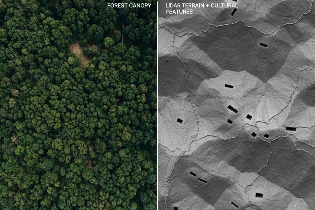
Welcome to remote metal detecting research, where forgotten homestead locations hiding under dense forest canopy become visible with a few mouse clicks. Free LiDAR data makes it all possible.
If you’ve been metal detecting for any length of time, you know the problem with site selection: most accessible historical sites are hunted to death. Those parks in local history books? Detected since the 1970s. That old homestead everyone talks about? Picked clean decades ago.
The best detecting sites are different though. They could fill your display case with hand-forged relics and early coppers, but they’re buried under 200 years of forest growth. Traditional site research methods can’t find them[1].
Learning how to use LiDAR for metal detecting changes everything.
- What Is LiDAR for Metal Detecting? (Your X-Ray Vision for Finding Historical Sites)
- Free LiDAR Data Sources: Best Sites for Finding Old Homesteads
- How to Read LiDAR Maps: Identifying Cellar Holes and Old Foundations
- Step-by-Step LiDAR Metal Detecting Guide: From Research to Discovery
- Metal Detecting Laws: Legal Requirements for Treasure Hunting
- Understanding LiDAR Resolution and Map Settings for Best Results
- Best Historical Sites for Metal Detecting: Colonial-Era Homesteads
- LiDAR for Treasure Hunting: Your New Secret Weapon for Finding Detecting Sites
- References
What Is LiDAR for Metal Detecting? (Your X-Ray Vision for Finding Historical Sites)
Think of LiDAR as X-ray vision for terrain, because that’s essentially what it is.
Here’s how it works: Aircraft fly over forests and shoot hundreds of thousands of laser pulses toward the ground every second[2]. These pulses measure distance by timing how long they take to bounce back, creating incredibly detailed elevation data.
The brilliant part? Modern LiDAR systems capture 5+ returns per pulse. Some laser beams hit tree tops and bounce back immediately, while other beams find gaps in the leaves and continue down to the ground[3]. It’s like the technology is peeking through the forest canopy.
Then computers work their magic. Software sorts which returns came from trees and which came from the actual ground, resulting in detailed LiDAR maps showing bare earth with all trees, brush, and undergrowth mathematically removed. You suddenly see features that have been invisible for generations.
For treasure hunting and relic hunting, this technology reveals the good stuff:
- Cellar holes from old homesteads (typically 10-20 feet across)
- Stone walls marking old property lines and field boundaries
- Old foundations and structural remains from forgotten buildings
- Forgotten cart paths and farm roads that haven’t seen a wagon in 150 years
- Wells, cisterns, and outbuildings that people used daily
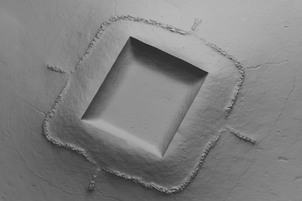
The accuracy is stunning – typically within 10-20 centimeters[4]. That’s precise enough to find cellar holes with LiDAR and spot a 12×18 foot colonial cellar even when it’s buried under three feet of leaves and surrounded by mature hardwoods.
Free LiDAR Data Sources: Best Sites for Finding Old Homesteads
Here’s what really changed my site research game: this technology is now completely free to access. Anyone with an internet connection can use it, which wasn’t always the case.
Professional LiDAR surveys used to cost $500-$1,000 per square kilometer[5], which put them out of reach for hobby detectorists. Now the USGS 3D Elevation Program has mapped huge areas of the United States and is aiming for complete coverage by 2027-2028[6]. They’ve made all this data freely available to the public.
Where to Access Free LiDAR Maps for Treasure Hunting
USGS LidarExplorer (apps.nationalmap.gov/lidar-explorer)
This is your starting point for finding old homesteads with LiDAR. The federal portal offers growing nationwide coverage with 3D visualization built right into your browser – no downloads, no special software, no GIS degree required[7]. Just open it up and start exploring.
State Portals
These are often better than federal sources when it comes to property search and historical homestead detection. States like Connecticut, Washington, Oregon, and Virginia have built dedicated LiDAR viewers that are specifically designed for public access.
Connecticut’s portal is particularly impressive because it integrates hillshade visualization with GPS tools, making it brilliant for using LiDAR to find detecting sites and old foundations[8]. I’ve spent hours on that platform and keep finding new features.
NOAA Digital Coast (coast.noaa.gov/dataviewer)
If you hunt coastal areas, this resource covers 550,000+ square miles of coastline with exceptional quality data and an incredibly user-friendly interface for LiDAR treasure hunting[9]. The coastal coverage is often higher resolution than inland areas.
Pro tip from my research workflow: Always check if your state has a dedicated portal before defaulting to federal sources. The state viewers usually have better tools and more intuitive interfaces that make interpretation easier. Virginia’s VGIN portal, for example, has a “terrain with labels” layer that experienced detectorists specifically recommend for maximum contrast when hunting cellar holes and forgotten homestead locations[10].
How to Read LiDAR Maps: Identifying Cellar Holes and Old Foundations
This is where art meets science, and honestly, it’s where most beginners get stuck.
Understanding what you’re seeing on LiDAR maps separates the detectorists finding colonial coppers from those staring at confusing hillshade images wondering what they missed. Learning to find old home sites with LiDAR requires training your eye to recognize specific patterns – it’s like learning to read music. At first, it’s just squiggly lines, but then suddenly it clicks and everything makes sense.
Finding Cellar Holes with LiDAR: Your Primary Target
These show up as rectangular or square depressions on hillshade visualizations, and they’re the key to finding old homesteads with LiDAR.
Pre-1800s cellars appear as simple square depressions, usually about 12×18 feet, and they often lack visible stone foundations because materials got salvaged for later construction. The key is looking for geometric regularity – nature doesn’t create 90-degree corners, so when you see them, pay attention.
Post-1800s cellars are different with their larger L-shaped or C-shaped patterns that show additions over time. These typically have better-preserved stone foundations that appear as slight rim elevations around the edges, and you might also spot bulkhead entrance features on one side where families accessed their root cellars.
The critical skill in LiDAR archaeology for beginners? Learning to tell human-made features from natural ones. Tree throws (created when large trees uproot) create irregular depressions with raised root mounds on one side and random distribution across the landscape. Human-made cellar holes are totally different – they have consistent dimensions, right-angle corners, and they hang out with other features like stone walls and are placed logically on higher ground with good drainage.
I’ve walked past dozens of tree throws thinking they were cellar holes. Once you train your eye on LiDAR for relic hunting though, the difference jumps out at you like a neon sign.
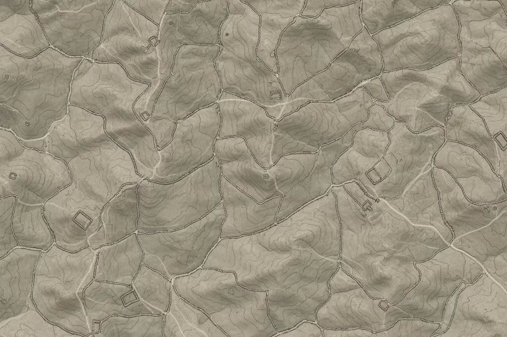
Using Stone Walls to Find Old Homesteads
Stone walls show up remarkably clear on LiDAR maps, even when they’re just inches high and completely buried under decades of leaf litter. Their unnatural straightness is the giveaway – nature rarely creates multi-meter straight lines cutting across varied topography.
Here’s the LiDAR treasure hunting tip that completely changed my success rate: Where extensive stone wall networks exist, cellar holes are always nearby. Always. Walls indicate agricultural activity, and agriculture required homesteads for the farmers who built them. Look for breaks in uphill walls along old roads because these mark entrance points to homestead sites.
One documented case study in LiDAR homestead hunting followed a clear road bed network up a Virginia mountainside and discovered 12+ linked homesites. Every single one was invisible on Google Maps satellite imagery, which just showed endless trees, but the LiDAR? Crystal clear.
Finding Old Roads on LiDAR: Trails to Forgotten Detecting Sites
Historical farm roads show up as linear depressions or slightly raised features running through forested areas. They’re narrower than modern trails, often flanked by stone walls on both sides, and they may show cut sections through bedrock where pioneers had to carve through obstacles.
These features frequently lead straight to homestead locations, which makes sense when you think about it. I now spend half my remote metal detecting research time just tracing old road networks on LiDAR maps because they’re like treasure maps – they literally point to forgotten sites where people lived and worked.
Step-by-Step LiDAR Metal Detecting Guide: From Research to Discovery

After two years of trial and error, here’s the workflow that actually works for finding old foundations with LiDAR.
Phase 1: Digital Reconnaissance – Remote Metal Detecting Research (2-3 hours)
Pull up your state’s LiDAR portal or USGS LidarExplorer and start scanning areas with known historical activity. Look for cellar hole candidates that have other features nearby – walls, roads, and signs of human activity that reinforce each other. Document GPS coordinates for anything promising and cross-reference with Google Earth to understand the modern terrain context.
Phase 2: Historical Verification – Site Research (1-2 hours)
This is where you confirm what you think you’re seeing. Check historical topo maps and atlases to verify old home sites actually existed where your LiDAR shows depressions. Review old aerial photographs if you can find them, and search census records for homestead confirmation. Always verify the site predates the 1950s because fresher sites mean more modern trash and fewer historical artifacts worth finding.
Phase 3: Legal Clearance – Property Search (Variable)
Determine property ownership through county GIS systems and verify it’s not federal land, because ARPA regulations prohibit detecting on federal lands without permits. Contact the landowner for permission – I have a standard permission letter I’ve refined over time that explains what I’m doing and reassures property owners. Always document your permission in writing before you set foot on someone’s property.
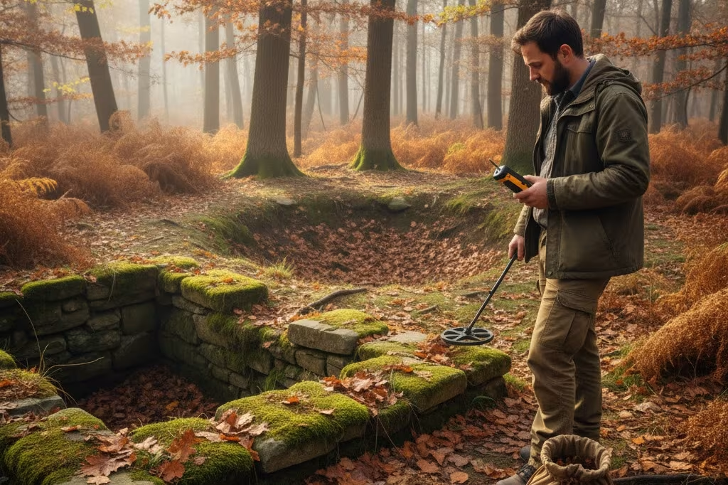
Phase 4: Ground-Truthing – Field Visit (1 day)
Visit the site to confirm features actually exist like the LiDAR maps showed. Assess accessibility and hunting viability because sometimes what looks perfect on screen turns out to be in a swamp or on a cliff face. Document site condition with photos, and if it’s confirmed productive, begin systematic metal detecting.
This process works, and I’ve used it seven times now to find seven colonial-era homesteads that were completely unknown before I spotted them on LiDAR.
Metal Detecting Laws: Legal Requirements for Treasure Hunting
This is critical, so pay close attention: Finding historical sites on LiDAR maps doesn’t automatically give you permission to detect them.
The Archaeological Resources Protection Act (ARPA) prohibits metal detecting on federal lands without permits, and sites over 50 years old with archaeological significance fall under these protections. Many states also have specific regulations for detecting on public lands, so you need to research your local laws before you start digging.
Your legal checklist for responsible treasure hunting looks like this: Always get explicit landowner permission through proper property search, never detect on federal lands without permits, respect “no detecting” signage on public property, and if you encounter significant archaeological features (multiple artifacts in context, structural foundations, burial grounds), stop immediately and report to authorities.
The metal detecting community’s reputation depends entirely on responsible behavior. One person ignoring these rules damages access for all of us using LiDAR for treasure hunting, so don’t be that person who ruins it for everyone else.
Understanding LiDAR Resolution and Map Settings for Best Results
If you’re the type who geeks out over specs (and let’s be honest, that’s probably why you’re reading this far), here’s what really makes a difference when using LiDAR to find detecting sites.
The resolution sweet spot for historical homestead detection is 1-2 meter DEM resolution, which is adequate for identifying cellar holes and major old foundations without overwhelming you with massive file sizes. Point cloud density of 1.5-meter post spacing or better provides the detail you need when learning how to find old home sites.
Understanding DTM versus DSM makes a practical difference in your site research. Digital Terrain Models (DTM) show bare earth – exactly what you want for finding forgotten homestead locations. Digital Surface Models (DSM) include all surface features like buildings and trees, which are less useful for LiDAR homestead hunting but helpful for understanding modern terrain obstacles during property search.
Hillshade visualization with lighting from the northwest (315 degrees) at a 45-degree angle provides optimal contrast for viewing subtle depressions on LiDAR maps. Most portals let you adjust these parameters, so experiment with different illumination angles because different feature types show up better with different lighting when learning how to read LiDAR maps. I spent hours tweaking these settings before I figured out what worked best.
Best Historical Sites for Metal Detecting: Colonial-Era Homesteads
For those of us who live for that moment when you unearth a piece of genuine history, the colonial period (pre-1800) is where the magic happens.
These forgotten homestead locations often predate real systematic mapping efforts, meaning many homesteads were abandoned and forgotten before anyone ever bothered to officially record them. Using LiDAR for relic hunting finds exactly what historical sites records completely missed – the ones that fell through the cracks of history.
Target areas with documented colonial settlement but minimal modern development, like New England, the Mid-Atlantic states, and Appalachian regions. These areas offer exceptional potential for finding old homesteads with LiDAR because they were settled early but often abandoned as settlers moved west or farming became less viable.
That 1787 Connecticut copper I mentioned at the beginning? The homestead wasn’t on any map I could find. Not county records, not historical atlases, nowhere. But LiDAR revealed what 230 years of forest growth had completely concealed – a perfect 12×18 foot cellar hole with stone wall networks leading right to it.
Understanding site evolution helps tremendously with interpretation. Early homesteads started small with just a simple cellar and basic structures. As families prospered, additions appeared. Kids got married and built nearby, creating family compounds. These growth patterns become visible on LiDAR maps once you know what to look for during your site research, and suddenly you’re not just seeing features – you’re reading the story of how generations of families lived and expanded their footprint on the landscape.
LiDAR for Treasure Hunting: Your New Secret Weapon for Finding Detecting Sites
LiDAR for treasure hunting doesn’t replace traditional metal detecting research tools – it enhances them in ways that weren’t possible even five years ago.
The best finds still require understanding history, respecting laws, building landowner relationships, and putting in the field time. But this technology gives you a genuine edge in locating virgin detecting sites that other detectorists simply don’t know exist because they’re still relying on old methods.
I’ve now found seven previously unknown colonial-era homesteads using this LiDAR metal detecting guide, and each one has produced finds that would have been completely impossible at well-known, over-hunted historical sites. We’re talking pristine colonial coppers, hand-forged hardware, buttons with regimental markings – the kind of artifacts that make your hands shake when you pull them from the ground.
The learning curve is real, and I won’t sugarcoat it. It took me probably 20 hours of screen time before I could confidently identify cellar holes versus natural features when learning how to read LiDAR maps. But it’s absolutely worth the investment because once that skill clicks, you’ll never look at historical research the same way again.
The detectorists winning “find of the month” contests at clubs? Many of them are quietly using LiDAR to find old homesteads, even if they’re not advertising their methods. The technology has become what experienced users call their “best kept secret” for finding old foundations and forgotten homestead locations that still have stories to tell.
Now it’s yours too.
So grab a cup of coffee, pull up your state’s LiDAR portal, and start scanning your favorite hunting areas from a completely different angle. You might just find that the best sites were hiding in plain sight all along, buried under a digital forest canopy and waiting for someone to actually look.
Happy hunting, fellow diggers. May your cellar holes be deep and your colonial coppers be plenty. 🔍⚡
References
[1] USGS 3D Elevation Program. “What is Lidar data and where can I download it?” U.S. Geological Survey. https://www.usgs.gov/faqs/what-lidar-data-and-where-can-i-download-it
[2] NOAA Office for Coastal Management. “Coastal Topographic Lidar.” https://coast.noaa.gov/digitalcoast/data/coastallidar.html
[3] USGS. “3D Elevation Program Standards and Specifications.” U.S. Geological Survey. https://www.usgs.gov/ngp-standards-and-specifications/3d-elevation-program-standards-and-specifications
[4] SciELO. “Vertical accuracy of the USGS 3DEP program data: study cases in Fresno County and in Davis, California.” https://www.scielo.br/j/bcg/a/pc9wjzfq6zzWN5kdfFgcPPr/?format=pdf&lang=en
[5] Friendly Metal Detecting Forum. “2025 LIDAR Project.” https://metaldetectingforum.com/index.php?threads/2025-lidar-project.310296/
[6] USGS. “3D Elevation Program – FAQs.” U.S. Geological Survey. https://www.usgs.gov/3d-elevation-program/science/faqs
[7] USGS. “LidarExplorer | U.S. Geological Survey.” https://www.usgs.gov/tools/lidarexplorer
[8] Equator Studios. “Top Free LiDAR (LAZ) Data Sources.” https://equatorstudios.com/top-free-lidar-laz-data-sources/
[9] NOAA. “Data Access Viewer.” https://coast.noaa.gov/dataviewer/
[10] Friendly Metal Detecting Forum. “Online Research (Maps, Old Homesites).” https://metaldetectingforum.com/index.php?threads/online-research-maps-old-homesites.301626/

My name is Paul and I am the founder of Detector For Metal, a dedicated resource for metal detecting enthusiasts seeking to uncover historical treasures and connect with the past using the latest technology. As a stay-at-home dad and family man, I’ve found metal detecting to be the perfect hobby that combines family adventure with historical learnings for the whole family.
As a father, I’m deeply committed to passing on this hobby to the next generation of detectorists, starting with my own children. I share advice on everything from metal detecting with kids to exploring the top 10 metal detecting sites you never thought about. My methodical approach to the hobby goes beyond the thrill of discovery—it’s about creating family traditions while preserving history and sharing the stories of those who came before us.

